- >>
- Youth

From last few years world has been experiencing some of the deadliest storms ever. Call it hurricane, tropical cyclone or typhoon they are the same havoc causing agents with different names. Indeed not happy with the damaged they have caused in all these years, this year may be a record breaking for them.
After Harvey, Irma and Jose, Maria the latest storm has began its path of destruction. The strongest hurricane to hit the US territory in 89 years, Maria has flooded homes and businesses with as much as seven to ten inches of water and destroyed already fragile electricity lines.
The consecutive string of deadly hurricanes has led to the perception that 2017 may be the worst hurricane season yet, while providing fuel for the ongoing debate about the effects of global warming. But what these tropical cyclones really are? How do they turn into such destructive machines? Why are they given such peculiar names? Let’s have a look
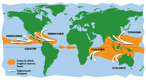
A tropical cyclone is a rapidly rotating storm system created above oceans. Depending upon its location and strength, a tropical cyclone is referred by different names.
When occurred in Atlantic or north-eastern Pacific Ocean it is called as hurricane, a typhoon when occurs in north-western Pacific Ocean and cyclone when it occurs in the South Pacific or Indian Ocean. Whatever they are called, tropical cyclones all form the same way.
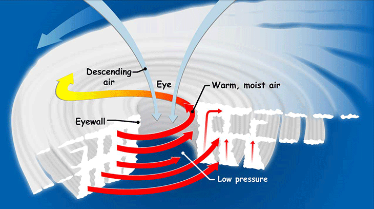
Tropical cyclones are like giant engines that use warm, moist air as fuel. That is why they form only over warm ocean waters near the equator. The warm, moist air over the ocean rises upward from near the surface, causing an area of lower air pressure below. Air from surrounding areas with higher air pressure pushes in to the low pressure area. Then that "new" air becomes warm and moist and rises, too. As the warm air continues to rise, the surrounding air swirls in to take its place. As the warmed, moist air rises and cools off, the water in the air forms clouds. The whole system of clouds and wind spins and grows, fed by the ocean's heat and water evaporating from the surface. Storms that form north of the equator spin counter clockwise. Storms south of the equator spin clockwise. This difference is because of Earth's rotation on its axis.
In this diagram of a hurricane, warm air full of moisture rises from the ocean surface (small upward red arrows). It forms rotating bands of clouds. Cool air (pale blue arrows dropping from top) sink into the middle of the storm, forming its “eye.” The rising and sinking air drives the air’s swirling movement (large red and blue arrows). Hurricane winds rotate counter clockwise in the Northern Hemisphere (and clockwise in the Southern Hemisphere).
As the storm system rotates faster and faster, an eye forms in the centre. It is very calm and clear in the eye, with very low air pressure. Higher pressure air from above flows down into the eye. Around this centre winds move at speeds between 74 and 200 miles per hour. When the winds in the rotating storm reach 39 mph, the storm is called a "tropical storm."
But swirling ocean-born storm clouds are not enough to qualify as a hurricane. The critical issue is wind speed. As a storm strengthens, its circulating winds will become more powerful. As long as the winds’ sustained speed does not exceed 61 kilometres (38 miles) per hour, this storm will be known as a tropical depression. If its winds continue to build, attaining 62 to 117 kilometres (39 to 73 miles) per hour, it will formally become a tropical storm. At this point, it will receive an official name — such as Katrina (2005 in the Gulf of Mexico), Nepartak (2016 in China and Taiwan), Roanu (2016 in the Bay of Bengal) or Harvey (2017 in the Gulf of Mexico).
Finally, if conditions are right, the storm can intensify into a hurricane (or typhoon or cyclone, depending on its location). These intense circulating storms are rated category 1 to 5 on the Saffir-Simpson Hurricane Wind Scale. That rating reflects the maximum sustained wind speed (as measured over a 2 minute period).
Tropical cyclones travel, often creating havoc far from the warm waters that first spawned them. Some may move hundreds to thousands of kilometers (or miles) across open oceans. Along that path, they may strengthen or weaken several times. Especially dangerous are storms that “make landfall.” This refers to their having crossed some island or coastline. Most hurricanes lose steam within a day or two of making landfall.
There is a predefined procedure established by the World Meteorological Organization. Until the early 1950s, tropical storms and hurricanes were tracked by year and the order in which they occurred during that year. Over time, it was learned that the use of short, easily remembered names in written as well as spoken communications is quicker and reduces confusion when two or more tropical storms occur at the same time.
In the past, confusion and false rumours resulted when storm advisories broadcast from radio stations were mistaken for warnings concerning an entirely different storm located hundreds of miles away. In 1950, a formal practice for storm naming was first developed for the Atlantic Ocean by the U.S. National Hurricane Center.
At that time, storms were named according to a phonetic alphabet (e.g., Able, Baker, Charlie) and the names used were the same for each hurricane season; in other words, the first hurricane of a season was always named “Able,” the second “Baker,” and so on. In 1953, to avoid the repetitive use of names, the system was revised so that storms would be named after female names. By doing this, the National Weather Service was mimicking the habit of Naval meteorologists, who named the storms after women, much as ships at sea were traditionally named for women. In 1979, the system was revised again to include both female and male hurricane names.
Hurricanes are defined by their winds. And those winds unquestionably pose a major threat to coastal communities. Steady winds and even higher gusts can blow down electric-power lines, upend trees, and toss debris through the air. Whole buildings can be knocked down.
The gusting, gale-force tempests can even transform branches and other types of debris into potentially deadly projectiles. But storm dangers are not due solely to the speed at which hurricanes blow. One of the greatest dangers that these storms pose to coastal areas is what’s known as a storm surge. As a tropical cyclone spins toward land, its winds can push seawater ashore. This may temporarily flood the land to depths of 1 to 4 meters (3 to 13 feet) or more.
A storm surge can be especially dangerous if it coincides with high tide; this can push an even higher wall of water onshore. Another hazard: Torrential storms may dump 25 centimeters (10 inches) or more of rain within 24 hours. These rains can fall too fast to soak into the ground, posing a risk of flash floods. This may occur inland, far from any storm surge. And these storms may trigger lightning and tornadoes, which pose their own risks.
Climate change remains a polarizing issue in our already divided world. And whenever a huge weather event like Irma or Maria occurs, a debate rages in the meteorological community about whether it is appropriate to discuss potential links between climate change and that specific event.
The background to these enquiries stems from a simple observation: extra heat in the air or the oceans is a form of energy, and storms are driven by such energy. What we do not know is whether we might see more storms as a result of extra energy or, as other researchers believe, the storms may grow more intense, but the number might actually diminish. A report released in 2016, stated that there is no evidence that the number of tropical cyclones (tropical storms, hurricanes and typhoons) have increased in recent decades as the planet has warmed. However, there has been "marginally significant increases in the frequency of category 4 and 5 storms."
The most recent draft of a sweeping climate science report pulled together by 13 federal agencies as part of the National Climate Assessment suggested that the science linking hurricanes to climate change was still emerging. Looking back through the history of storms, “the trend signal has not yet had time to rise above the background variability of natural processes,” the report states.
Temperatures have been rising, and theory and computer modeling suggest an increase in storm intensity in a warmer world, “and the models generally show an increase in the number of very intense” storms. And while the science of attributing weather events to climate change is advancing, “studies of individual events will typically contain caveats,” the report stated.
Katharine Hayhoe, a climate scientist at Texas Tech University and an author of the report, said even if global warming does not change the number of storms — and, she noted, there could even be fewer hurricanes over all — tropical storms and hurricanes do gain energy from warm water, so the unusually warm water that has accompanied climate change “can have a role in intensifying a storm that already exists.”
More moisture in the atmosphere, she said, means the amount and intensity of rain associated with hurricanes and other storms is growing. While people might think of high winds and storm surge as the risks of hurricanes, she said, “Freshwater flooding is potentially a much greater problem than the storm surge.”
“We care about a changing climate because it exacerbates the natural risks and hazards that we already face; People always want to know is it climate change or is it not? The answer is it’s in between.”
Nature bears long with those who wrong her, She is patient under abuse,
But when abuse has gone too far,
When the times of reckoning finally comes,
She is equally slow to be appeased,
And to turn away her wrath
-Nathaniel H. Egleston (1882)