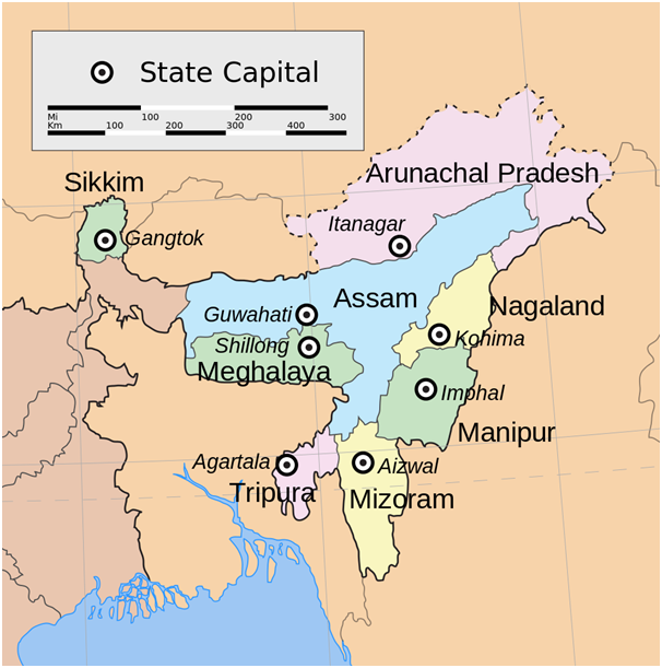
Connecting Northeast India
Just a map?

KOLKATA: It was first called the Look East Policy. It is now renamed as the Act East Policy.
Governments change and so does the nomenclature; what does not change is the fact that India’s Northeast remains disconnected from the rest of the country. This disconnect is not just in the geographical realm, but also at the level of the superstructure.
With the advent of newer forms of communication, research also has undergone change, and the 21stcentury India now sees a plethora of research organisations or think tanks springing up which aim to study in detail the eight states in the region called Northeast India. While this actually should have been a welcome change just the way the increasing number of policies at the level of the state which aim to connect the region with the rest of the country should have been, fact remains that these newer methods of exchange of ideas seem to be just as redundant as the past policies.
With little or no knowledge of the region or its history, languages or cultures, the information disseminated do little or no good to the region. What is additionally frustrating are the inane attempts at ‘research and information dissemination’ which further adhere to the already prevalent stereotypes about the people and the region.
This disconnect which begins with the lack of physical infrastructure and meanders into the lack of understanding at the level of the superstructure has been a stark reality ever since the independence of the country, and it continues to exist to date. While it is difficult to understand if it is the lack of physical infrastructure that shapes the close to zilch knowledge about the culture, languages, peoples and even existence in Northeast India or if it is the other way round, fact remains that these forms of disconnect need to be addressed.
In terms of geographical connectivity, a closer look at connectivity between West Bengal and Sikkim has actually quite a lot to tell. Trade between these two Indian states can actually be traced back to the 2nd century BC. The Silk Route was an important route for trade and in Sikkim it is an offshoot of an ancient trade route which came from Lhasa, crossing Chumbi Valley and passed through the Nathula Pass and finally took to the port of Tamralipta, which is presently known as Tamluk in West Bengal. Even in the 21st century, a regular flow of traders and goods between the two states is a regular feature. The road connectivity between these two is through Siliguri. The Siliguri corridor- also known as the Chicken’s neck is the narrow stretch of land in West Bengal which connects West Bengal with the northeastern states of the country. The countries of Bangladesh and Nepal lie on the two sides of the corridor with the kingdom of Bhutan lying on the northern side of the corridor. Thus, this stretch is of particular importance for trade.
While government websites and other websites on information for tourists state public transport is easily available, fact remains that even when the road connecting Siliguri and Gangtok is not blocked due to landslides, public transport that could definitely aid travellers, tourists and traders is not well developed at all. The shared jeeps that are among the cheapest modes of transport do not have any specific method of operation, do not issue receipts for payments made, and are definitely not monitored by any governmental agency. Safety standards of the jeep, needless to say are below what would be required in the face of a calamity. There are no warning mechanisms and the drivers rely on information exchange among themselves on the road to analyse the situation on the roads. The latest landslide on June 23, 2015 actually led to a roadblock. However, as must have been the case many times, this time as well, the drivers and the travellers were stranded on the national highway connecting Siliguri and Gangtok.
What is interesting about the road connectivity here is that a blocking of this highway leads to a everything coming to a standstill. Nevertheless, as risky as it is, for the ones who deem it essential to take the journey even when the road is blocked, the road through Pankhabari is an option. The road is steep as it is first an uphill climb. The road also is extremely curvy and narrow- narrow to the extent that at places it is possible only for one vehicle to move. While this is meant only to be a one way road for coming down to Bagdogra or Siliguri, local drivers sometimes trick guards at check posts and go all the way up to Darjeeling. However, given the fact that the region is a landslide prone region, attempts could be made at developing this route as a proper alternative route, reducing and eliminating the risks attached in the form of an extremely narrow kachcha road.
The other need of the hour would be bringing the modes of transport under the ambit of a government agency- which also could ensure that the vehicles are at least fit to ply on the roads and are equipped with adequate facilities. This example may be one, but fact remains that an adequate study of not just this particular route but also of other routes in the region remains. Layperson suggestions of just building roads in the region have been quite a few in the past. Whole even those suggestions still remain on paper, what is urgently required is a thorough study of the region and its requirements- which hopefully someday could eliminate the lack of connectivity the region has with the rest of the country.
(Courtesy: thethumbprintmag.com)
(Sriparna Pathak Raimedhi is Associate Fellow, Observer Research Foundation, Kolkata 700156, West Bengal, India)


